
Pre Agung
So let me set the scene. Sat in a hotel in Kuta on the island of Bali, Indonesia, with my girlfriend Molly, who I had not seen in just over eight weeks, I popped out for fifteen minutes to grab some cash. Since visiting Bali the year prior, climbing Mount Rinjani has been on Molly’s bucket list and since Rinjani was so close on the neighbouring island of Lombok, we had booked a four day, three night Rinjani trek in advance.
We had only given ourselves a few days to travel and rest before starting the Rinjani trek, however, upon my return from the cash point, suddenly the Rinjani trek could wait…
“I think we should climb Mount Agung while we’re here,” says Molly, as she shows me a simply stunning video of the sun breaching the horizon from the summit of Agung. “It will be good preparation for Rinjani,” she continues. And preparation it was, of a devilishly evil, yet most rewarding kind.
Fast forward a few days and we’re standing in the remote Besakih region at 11pm in the somewhat freezing cold, with a 3,000 metre summit attempt and overnight hike ahead of us. Oh and the prospect of the “main” multi day hike on a completely different island in three days time!
Lurking stealthily above us, made invisible by the gloom of nightfall, was Mount Agung; an active volcano representing the tallest peak on the island of Bali – standing 3,031 metres above sea level. The Balinese believe Agung to be sacred, therefore, hikes to the summit are viewed as a spiritual journey. Upon ascending Agung, we were told we would see multiple Hindu offerings along the way – a traditional method of expressing thanks for a safe passage up the mountain.
A safe passage can not be taken for granted however. Due to Bali’s position on the Pacific ‘Ring of Fire’, severe seismic activity is not uncommon due to tectonic plate collisions. Although Agung’s last major eruption was in 1963, causing over 1500 fatalities, the surrounding area was last evacuated in 2017 due to high risk levels of eruption.
Ascending Agung
Although clearly dangerous, I must admit that when you are standing at the trailhead in the pitch black, somewhat un-Balinese temperatures and facing a sleepless night, the threat of an eruption really does not worry you. We seemed to be more questioning why we were doing this, no one had made us sign up. I kept reminding Molly that it was her bright idea back in Kuta…
Alas, the best way to move past the blame game was to get one foot in front of the other and start the summit. Joined by our guide, Ketut, and armed with our packed breakfast of cheese and chocolate sandwiches and a boiled egg, the first mission was to climb high enough to break the treeline. The ascent at this point started steadily uphill, not that we could gauge much more about our surroundings. The illuminated metre or two in front of us from our head torches was all we possessed in our arsenal to navigate the initial proceedings. Sensing as though they felt like it was their duty, the village dogs escorted us out of Besakih. Ketut then told us that it was not uncommon for the dogs to continue all the way to the summit with hikers, sadly though our dogs clearly felt they had fulfilled said duties and headed back to bed. Can’t be blamed.
The trees began to subside, giving way to a magnificent trail of head torches snaking their way up the mountain above us. This was both reassuring as we could see our route, yet, the fact the torches seemed so close yet so high, really illustrated the task literally ahead of us. However, due to those ahead of us intricately navigating the narrow, gully-like paths in front, we were given time to pivot one hundred and eighty degrees; it was at this point the appreciation of where we were really started to set in.
Although shrouded in darkness, the dazzling lights of Balinese villages below dramatically portrayed the sense of height. And we were barely a quarter of the way to the summit! You could be forgiven for thinking you were standing on the edge of the world, as the dancing village lights below did their best impersonation of the stars that lit up the night above.
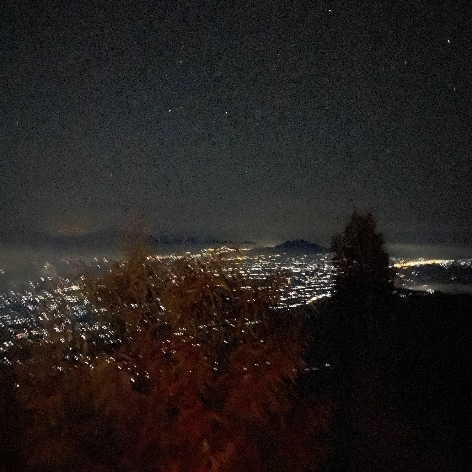
The sense of height provided by the illuminations below provided a feeling I’m not sure I had felt before. I couldn’t tell you why; perhaps it was knowing the lights went on for miles until reaching the all encompassing ocean. Or the fact that behind us the sleeping giant of Agung was patiently waiting to greet us, with what one would imagine to be even greater views.
We ploughed onwards; the going was impossibly steep now. Our legs were burning, sweat was pouring, and our lungs were constantly filling with dust from the baron pathways. A standard 2am on a Sunday night.
After another solid two hours of hiking, a bigger break was in order in the hope of diminishing the sense of delirium that was rather apparently creeping in. Despite still bathing in complete darkness, our internal feelings and emotions became excessively heightened. As we sipped our grainy Balinese coffee and acknowledged a fellow hiker – apparently determined to take his guitar all the way to the summit with him – the realisation of where we were and what we were doing became prominent once more.
It was 4am. Over 7000 miles from home. Halfway up an active volcano. And I don’t think I was hallucinating the man with the guitar… What a truly special experience we were living, and it was only going to get better.
This pause in the trek was longer than others we had previously savoured and the plummeting body temperatures while stationary was a stark indicator of just how hard our bodies had been working when on the move. It is no shock though. The dusty, dessicated paths engulfing one’s foot genuinely made it a two step forwards one foot backwards situation. These were not the only challenges the conditions underfoot threw up, but we’ll come back to that later.
“How long until the summit?” I asked Ketut.
“At least two hours,” he replied.
Now in the grand scheme of things that doesn’t sound a lot, but let me tell you, when you last properly slept 19 hours ago and you’re faced with another two hours uphill… that seems like a big ask.
As we slogged upward, the term ‘uphill’ became somewhat of an understatement. The trail turned to rock, providing more solidarity under our feet, yet causing added brutal physical exertion. At points we were on all fours, at points we were hoisting each other up small cliffs, at points we really were questioning what we were doing. Again.
Progress, eventually, started to be made though. With conditions sturdier under foot, we started to gather the sense that we really were covering some distance. And at this point I would like to stress how much we were enjoying it. Yes, the majority of this piece may hold a tone of complaint and exhaustion, however, that was oddly kind of exactly what we were after.
You see, both myself and Molly are believers that you have to earn the rewards you seek in life. In this particular instance, the only thing on our minds was to summit the bastardly beautiful Agung by sunrise. That, and how much we wish we had brought a bloody Fanta with us. Continuing to ignore our thirst though, if it was possible to summit Agung in an hour, or by cable car, then I probably wouldn’t be writing this piece today; and we wouldn’t have half the memories and stories to cherish.
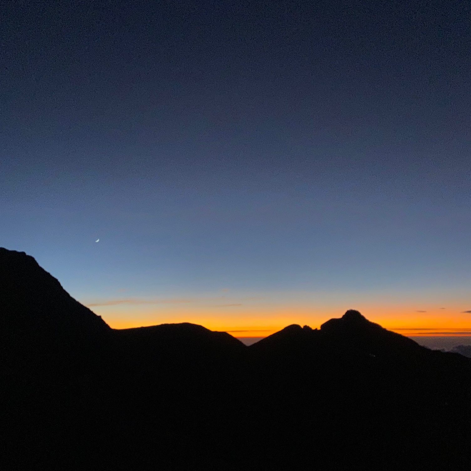
So, although knackered and dreaming of doing anything other than hiking, the determination deep inside us was spurred on by the night sky revealing the first slither of dawn breaking.
First a deep, spectacular purple; then a gloriously, glowing orange; split by a piercing, yet subtle pale yellow. The sky had truly become the momentary, mesmerising main attraction.
This definitely provided a much needed lift in spirits. It was also only at this point that we could fully appreciate the sheer, raw beauty of our surroundings. Being as high up as we were ensured that daylight took over surprisingly quickly, even if the sun had not yet risen.
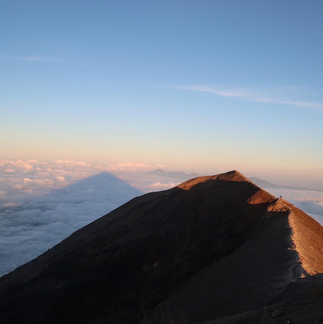
Purples turned to blues, with the glowing orange adopting a warm tone – signalling the sun’s ever nearing appearance. Endeavoured to enjoy the sunrise at our end destination of 3,031 metres high, the rocky traverse had given way to an incredible ridgeline – possibly marking my personal pinnacle of the whole experience. The morning light illuminated the breathtaking route to our finishing point, as sheer as it may be.
Of course we felt obliged to take some pictures, and there was the occasional mission to find a secluded wee spot – on what was one of the most exposed points you could possibly find by the way! But even with these distractions and stoppages, at roughly 06:14am we had done it. The highest point in Bali.
Nearby peaks of Mount Batur and Mount Merbuk resembled islands amongst a sea of clouds. We had a full 360 degree view of Bali, with sights of neighbouring islands Java, Gilli and Lombok. The latter rather suitably showed us our next challenge of a couple of days’ time, Mount Rinjani. But for the time being, we had to be present and take in all of our surroundings. Molly and I had both visited the Gilli islands which were visible but seemingly tiny; providing us with a sense of massiveness, despite having felt miniscule at numerous points when in Agung’s shadow.
So that was it, it was all downhill from here. Our bed was calling and we’d soon be there. Or so we had assumed.
Descending Agung
Having been so consumed in what was the physical and mental toil that the summit had provided us with, the thought of the descent had been completely neglected. The slippery paths and sheer slopes we had traversed throughout the night hadn’t been worth an ounce of thought of what it may be like on the return leg. Little did we know we were about to experience the toughest, most grueling part of the hike.
We had been told we would return to Besakih at 13:00 pm the next day, upon being dropped at the starting point. Only now at the summit did it sink in that we faced the same, if not longer, amount of time as the ascent to return home.
Even heading back along the ridgeline, the differing perspective and ever growing daylight, illuminated more and more why it would take so long to return. We were quite comfortably above the clouds, by some distance; you half expected to see an airplane right in front of your nose.

Soon enough Agung’s gradient plummeted, so much so you felt as though you could almost fall off the volcano once more. The rock faces we had scrambled up on all fours now posed a much more genuine threat. Not only due to the uneven surface meaning rolling your ankle was more or less a guarantee, but also the tiny loose chunks of rock turning this stage of the descent into a slip and slide.
We adopted the sideways approach. Imagine Agung was a black ski slope and Molly and I had never skied before. We were gingerly zigzagging our way down but most importantly, with our ankles still attached to our legs.On the odd occasion a local shot past us, leaving myself and Molly genuinely in awe and denial as to how they, to us, could be risking their life so casually – those crazy four year olds on the ski slope if you will.
Eventually the rocks gave away to our old friend of the wizened, dirt paths. Still ominously high above the clouds, we continued downwards and although there were no longer loose rocks, the fine dirt and sand meant we had not escaped the slip and slide.
Hour after hour passed and we were still above the clouds. I can’t write anymore however, without stressing Ketut’s patience with us. This man traversed these slopes three times a week – he could fly down the mountain and be tucked up in bed before we’d made it back under the clouds! But of course he didn’t. Instead everytime we apologised for being cautious, his response was to remind us this was his job and his job is only done well if we returned safely.
As we ever so judiciously made our way lower and lower, we could see why returning safely was the most important thing on Ketut’s mind. The conditions underfoot, mixed with the gradient of the slope, made it so slippery that we lost count of the number of times either Molly or I went tumbling. The threat of falling was comparable to that of being on an ice rink, having zero skating experience. Either you concentrated on gravity not pulling you downhill – which often resulted in overcompensating and slipping backwards – or you let gravity do its thing; hoping there was a tree, branch or in our case, a friendly local guide, at the bottom of that particular decline to catch you as you hurtled uncontrollably towards it.
At this point it had just passed 9am. Realistically we knew we had four more hours of torture ahead of us, but the brutality of the descent, mixed with the fact we had been on this mountain for over ten hours now, meant we were in a strict sense of denial. Surely, we had to be close to the end…surely.
Upon the next of many, much needed breaks we had a look at Strava. We had been tracking the hike since setting off at 11pm the night prior, the reading though was unbelievably grim.
I can quite confidently say, never in my life have I been so dumbfounded and perplexed as I was upon seeing how relatively little progress we had actually made. Words will never do it justice. We zoomed out on the map showing where we had started, where we had summited and where we had to return to. Disbelief was rife.
“This has to be wrong,” I said, genuinely doubting the technology, “It can’t be tracking us accurately!”
However, Ketut confirmed what we wished Strava had not told us by revealing we had only completed about a quarter of the return leg, the brutality of the descent was well and truly upon us.
After this, Molly and I’s spirits went up and down. We’d go ten minutes without talking, purely concentrating on staying on our feet. We’d then find ourselves hysterically laughing at how inexplicably tougher the descent was compared to what we had thought, fuelled impeccably by severe sleep deprivation.
To further our dismay, it was only at this point that Ketut was eventually pointing out the spots we had rested at whilst on our way up all those hours ago. This meant progress became easier to measure but dread continued to cloud our emotions; those rest spots had felt hours into the ascent!
On we went. Stumbling. Falling. Crying. Laughing. Wincing. Falling some more. But eventually, the land ahead of us fell flatter, the clouds were again above us and civilisation loomed once more.
As we reintroduced ourselves to our driver, who had been waiting for us to return the whole time, we felt similar to how explorers must feel upon returning from a treacherous voyage – a modern day Christopher Columbus if you will.
Everything ached, from our eyelids to our toenails. Everything was filthy, from our knees to our backpacks. And everything was floating… but that was probably the tiredness.
A quick rinse in a local basin and having said our goodbyes and expressed our sincerest thanks to Ketut, we were settled in for the hour or so journey home. We had done it. And needless to say we were asleep within that car inside the first minute.
Post Agung
It is now a number of months since we conquered Agung and I feel as though one of the most important parts of the trek is reflection. It is true it is comfortably up there as one of the most physically challenging experiences of my life. It is true there are times when I found myself wishing I could teleport home. And yes, we were aching for a few days afterwards. However, I can comfortably say it was also one of the most magical, rewarding, fulfilling experiences of my life and something I would recommend to anyone. The stars of the night sky, the colours of dawn breaking, the views of the Island of the Gods were all truly worth the toils of making it up and back from the volcano’s summit.
For me, the beauty of Agung is it answers questions. What is the most physically challenging endeavour you have encountered? Mount Agung. What is the most memorable sunrise you have seen? Mount Agung. What should you do when visiting Bali? Mount Agung.
Suksma for a safe passage, you will continue to be spoken of for generations to come, Mount Agung.

Leave a comment